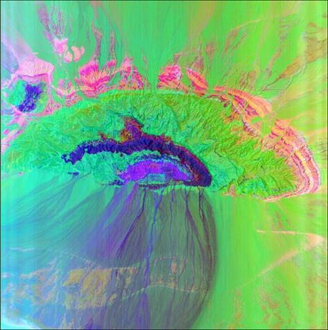
This mushroom-like (or jellyfish-like) geologic target is located in the heart of the desert in Iran. What makes this site so unique is the succession of ash tuff, breccia, lava, and intrusive acidic rocks bounded by a thick layer of carbonate sedimentary rocks deformed by an anticlinal structure and thrust faulting at the southern edges of the edifice. All of these make the site very appealing to study using the EnMAP hyperspectral data. The EnMAP data acquired on August 2022 provided an unprecedented level of information about the lithology and mineralogy of the area including the chemistry of carbonate rocks varying in composition from calcite to dolomite (beige to pink), the lithology of the subvolcanic rocks in the middle dominated by breccia, ignimbrite and ash tuff (green), and the central core dominated by acidic alterations superimposed on basic lava (dark blue: mainly of illitic white mica with low Al contents), granite to granodiorite intrusive rocks (purple: characterized by Al-rich muscovitic white mica), and tuff and sandy tuff (dark red). At the left tail of the purple core, alunite mineral was also spectrally remotely detected. The erosional tails in the nearby plain are also well depicted and characterized by the data. This colorful image was made by compressing 220 spectral bands into three band combinations using the principle component analysis augmented by a shaded relief digital elevation model in the background to give some impression of the topography. Such a richness of information for geologic studies is made possible by the EnMAP hyperspectral data thanks to its high spectral resolution, high signal-to-noise ratio, and free accessibility.